Background
FEMA revised flood maps for the Papillion Creek Basin, which identified significant changes in flood mapping depths and extents within the basin. These changes would have impacts on flood insurance rate premiums for some high-profile areas of commerce—including Aksarben Village, Altech, and throughout the West Branch sub-watershed—where a large share of the metro area’s growth is taking place.
In 2008, after a previous round of FEMA remapping that yielded discouraging results, Houston Engineering, Inc. (HEI) staff made recommendations to the Papio-Missouri River Natural Resources District (P-MRNRD) to revisit hydrologic and hydraulic methodologies within the watershed to try and develop a more reliable, better calibrated model. Collectively, it was believed that the additional modeling effort along with the construction of the West Branch dams WP-5, 6, 7, and 15-A would counteract increasing floodplain boundaries. The P-MRNRD asked HEI to revisit those recommendations resulting in this modeling effort.
The Project
HEI contracted with Applied Weather Associates (AWA) to develop several hydrometeorological assessments within the watershed specific to the basin/sub-basin sizes and locations. First, areal reduction factors (ARFs) were assessed for basin sizes in the watershed. These ARFs would be used to apply reductions in storm rainfall amounts to watersheds of various sizes. Next, storm distribution (temporal) patterns were developed for the Papillion Creek basin. This would provide a more accurate storm distribution than some of the new regional distributions used in NOAA’s Atlas 14 that accompany the newer, higher rainfall totals.
These two factors were the primary changes made to the basin’s hydrologic model. The effect of the dams built and planned to be built were also considered.
To calibrate the revised model using historical storms where detailed gage data was available, AWA developed temporal and spatial distributions of the rainfall events using NEXRAD data. That storm information was provided to HEI to run through the revised hydrologic and hydraulic models.
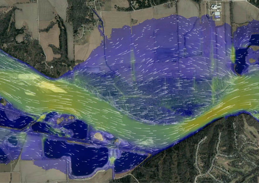
Preliminary results show a significant reduction (up to 30%) in water surface elevations and the associated inundation limits of the 100-year frequency flood. FEMA approved these results and the data was used in the last set of preliminary maps that were developed for the watershed in 2022.